Pages

Walking Tenerife's Badlands

Puerto de Güimar
Last week, I finally got around to walking the Malpais de Güimar, the volcanic coastline close to Puerto de Güimar on the east coast of Tenerife. This walk has been on my 'to do' list for some time and while it doesn't present much of a challenge either in time or effort required, it did prove to be a fascinating walk. Starting from the pleasant, if unremarkable seafront of Puerto de Güimar, the walk starts by an information board at the edge of the malpais and there are a couple of routes to choose from.

The Malpais de Güimar
I decided to follow the coastal path to the village of El Socorro and then return through the lava-fields at the base of the volcanic cinder cone of Montaña Grande. The word 'malpais' translates as 'badlands' and almost any area of volcanic wasteland in Tenerife gets saddled with this rather sinister sounding title. The lava in this instance issued forth from Montaña Grande a mere 10,000 years ago, so the area, geologically speaking, is in it's infancy. I was fortunate enough to have picked a gloriously sunny morning for my walk and set off from the edge of the village, passing ramshackle fisherman's shanties on the edge of the shore.
The Salt Flats
I followed the well-defined path as the sun sparkled on the Atlantic Ocean, the dramatic mountains of the Güimar Valley forming a fantastic, contrasting backdrop to the black, cardón strewn lava. As I approached the next information board, I noticed a number of flat, rectangular areas set in the lava and the board explained that these were 'slat flats', where sea water would become trapped and evaporate in the sun leaving behind the sea salt. Continuing, I arrived at the 'summit' of Montaña de la Mar, which at 27 metres above sea-level, barely qualifies for the title 'montaña' but on the top I found another information board explaining how the malpais came into being. The elevation, though modest, also gave an excellent aerial view of the lava fields. After around an hour of walking, I arrived at the village of El Socorro. Here, I found a pleasant stretch of black sand beach, which provided an excellent opportunity for a breather and I sat for a while in the hot sunshine watching the waves breaking on the shore before heading off through the village to locate the return path.
Montaña Grande
El Socorro, although pleasant enough, is unfortunate in that it has a large industrial estate backing onto it and as I left the village, I skirted the edge of the incongruously situated warehouses before picking up the path to Montaña Grande. Leaving the industry behind, I now followed a wide path to the volcanic cone, where it became covered in sand and yet another information board informed me that this originated from the beach at El Socorro, having been blown there by the wind. There are two routes around the foot of the cone and I had chosen the one closest to the sea as the other paralleled the TF1 motorway too closely for my liking. From Montaña Grande, I followed the easy path back to Puerto de Güimar, where I relaxed with a drink in the square on the seafront at one of cafes after a fairly easy but fascinating walk of around three hours.  

The View from Roque Imoque

Roque Imoque is a mountain that is familiar to all visitors to the south of Tenerife, although many may not know it's name. Lying just inland from Playa de Las Americas and Los Cristianos are the peaks of the Adeje Mountains and Roque Imoque, with it's needle-point summit, is one of the most recognisable. There is an easy path from the pass below the summit, although if you want to get right to the very tip, some scrambling skills are required as there is a rocky pinnacle on top with sheer rock walls providing a fairly tricky climb to the point of the 'needle'. However, there is a path just below the summit, which affords fabulous views of the surrounding countryside, including the other neighbouring peaks and also down to the coast and inland to Teide on a clear day. 

The needle-point summit of Roque Imoque
The nearby summit of Roque del Conde from Roque Imoque. The resort area of Costa Adeje can be seen in the background
The nearby twin-peaked summit of Roque de Los Bresos. Both this and Roque Imoque can be climbed from paths starting at the threshing circle visible in the bottom-right of the picture.
Looking south to the coast and Los Cristianos and the volcanic dome of Mt.Guaza. The 'rift' in the landscape is the Barranco del Rey with the peak of Roque del Conde to the right. 
The view inland across the Ifonche plateau to Teide and the National Park


Exploring San Miguel in Tenerife

Not too far from where I live in the south of Tenerife is the small hill town of San Miguel de Abona. Passing through the main street, it's easy to think that this slightly sleepy, fairly typical Canarian town has little of interest for those visiting the island but for anyone taking the time to leave the main road and investigate the narrow back streets, there is much of interest to be found. 
Salto del Pastor sculpture

Recently, in line with many other areas of the south, the walker is being catered for as numerous signposted hiking routes have sprung up, including two passing through San Miguel to Aldea Blanca. Even more recently, a town walk has been created taking the casual stroller on an interesting ramble around the back streets of the old part of the town, following newly installed information boards highlighting various points of interest to be found along the way. As you enter the town from San Lorenzo, you arrive at the Mirador de Las Palmeros, where you will find a map detailing the walk and marking points of interest. The mirador is easily identified by the unusual sculpture of a shepherd practising an ancient method of travelling quickly across steep, rugged terrain called Salto del Pastor, in which a large pole was used to negotiate steep slopes and ravines. This technique, which is believed to have been first been used by the Guanches, the islands original  inhabitants, has now been developed into a folk-sport. 
El Calvario
From the mirador, the walk heads for El Calvario, in the old part of town, where you will find the La Casa del Capitan. This traditional old Canarian house belonged to the Alfonso family until the end of the nineteenth century and Miguel Alfonso Martinez achieved the highest military rank in the municipality, which is where the house gets it's name. After the house was devastated by fire, it was purchased and restored by the town and now houses an historical and ethnographic museum. The walk heads along the Calle de La Iglesia, towards the church square, following the route of an old Camino Real, or Royal Way, that once connected the towns of Granadilla, San Miguel, Aldea Blanca and San Lorenzo with the north of the island. 
Calle de La Iglesia
This camino would have once been used by vendors selling or trading goods from village to village as well as shepherds moving their herds. The walk now passes La Vieja Bodega, where you can join El Camino de Las Lajas, a 3.5 kilometre signposted hiking route to the village of Aldea Blanca. This is another camino that besides the normal traffic of shepherds and vendors selling wares, was also used as a  'corpse road' with the dead being transported from Aldea Blanca to San Miguel for burial. As you continue along the Calle de la Iglesia, you will pass a small alleyway, which was once the site of a gofio mill and a generator, which was installed in 1922, making San Miguel the first municipality in the south of the island to have electric street lighting.  
House in the old part of San Miguel
Eventually, the walk arrives at the attractive church square shaded by Indian laurels. From here, there are superb views down across the town to the south coast and you will also find benches where you can rest in the shade and enjoy the peaceful atmosphere.
Church in San Miguel
Other buildings of interest in the square include the old library and birthplace of a famous Canarian, John Bethencourt Alfonso, a doctor, historian and anthropologist, who wrote 'The History of the Guanche People'.

Part two of the 'Crater to Coast Walk - Vilaflor to La Centinela' from 'Discovering Tenerife on Foot', follows the Camino Real from the Plaza de La Iglesia through the town to La Hoya and beyond to La Centinela.

Walking to Montaña Colorada, Tenerife.

Yesterday, I walked from the boundary of the Las Cañadas National Park to the red volcanic cone of Montaña Colorada. The walk descends on forest trails giving excellent views of the surrounding forests of the Ifonche region and also the Adeje Mountains. The weather was very hazy, which restricted the views to a degree but I was still able to get some reasonable shots during the walk.

El Sombrerito at the start of the walk, near the entrance to the Las Cañadas National Park. Pico Viejo and Mt.Teide can be seen in the background.

Walking in the Teno Mountains

I have been busy guiding recently and as I sat having a post walk drink and chat with one of the walkers, I realised that one of the things that gives me most pleasure when showing people around this wonderful island is their reaction to some of the stunning scenery.

Masca from the summit of Pico Verde
This was brought home to me particularly this week as I led a walk in the Teno Mountains on a route above Masca. I have walked this route many times in the past and although I never tire of the superb views into the Masca Valley, it was nice to have my eyes 're-opened' by the reactions of those seeing them for the first time.


The Teno Mountains
Upon reaching the vertiginous summit of Pico Verde, we enjoyed spectacular aerial views down to Masca hundreds of feet below, while a strong wind made us ever mindful of the narrow ridge we were perched on. Later, we climbed to the summit of Pico de Gala, which is a much more sedate affair as an access road leads all of the way to the communications aerials and fire tower adorning the summit. 
The Palmar Valley
From here there are more stunning views to Masca and also the Palmar valley, as well as La Gomera and the coastline of Tenerife. Later, as we emerged from a magical section of laurisilva forest, we were greeted by the sight of the majestic peak of Teide and it's near neighbour Pico Viejo. 
Teide & Pico Viejo 
Although I never tire of this view, it was nice to hear the enthusiastic comments of others to remind myself just how lucky I am to be living here on this beautiful island.    

Walking to The Deserted Village in a calima

The Deserted village of Las Fuentes
During the recent calima I walked the 'Deserted Village' walk from the book, which in the event proved to be a mistake. I had suggested the walk to a friend who was visiting the island and a day or so before he arrived, a weather warning was issued on the island for high temperatures but we decided to go ahead regardless.

Cave house in Las Fuentes
Walking in Tenerife can often be quite a 'perspiration soaked' affair and never more so than in a calima, a hot, dusty wind from the Sahara, and I have never walked in one quite so hot as this proved to be. As the day wore on the temperatures soared into the high thirties and what would normally be a perfectly manageable walk of around 3.5 hours became a 5.5 hour test of endurance!


Finca Montiel
The route to the mostly abandoned village of Las Fuentes crosses three barrancos (ravines) and temperatures in the bottom of these must have been hitting the 40c mark. Crossing the barranco streambeds and climbing out of the opposite side felt a little like walking through an oven as the heat retained in the rocks of the barranco walls radiated outwards and felt as though the central heating had been accidentally turned onto high! It is always advisable when walking in Tenerife to take plenty of water and soft drinks, I always carry a minimum of 2.5 litres and frequently drink all of it, particularly in the summer. In this instance I had three litres with me and and could have probably drunk even more.
The Island of La Gomera from El Choro
Approaching the village of El Jaral, we struggled in the searing heat as we climbed very slowly out of the last barranco of the day before following the road downhill back to our car. The cold beers after the walk that we enjoyed on the way home never tasted so good! Although I have walked in some of the less intense calimas, it is advisable to avoid strenuous exercise during these periods, which normally last for two to fours days. So if the air suddenly fills with a fine 'mist' and the temperature rises it's probably a good idea to find a shady spot, pour yourself a cool drink and leave the walking to another day. Check the 'Amendments and Updates' at the top of the page for the latest route information. 

Walking from Tenerife's National Park to it's highest village


Yesterday, I caught the once a day bus to the Las Cañadas National Park to the start of a walk from the Parador to Vilaflor, the island's highest village. The route involved a climb to the Ucanca Pass and then onto the summit of Montaña Guajara, from where I planned to descend on the GR131 to the Lunar Landscape and eventually onto Vilaflor to catch the return bus. It meant I had to keep up a good pace as I only had 5.75 hours to get back to Vilaflor to catch the bus.


The Parador with Tenerife's 2nd highest peak, Pico Viejo, in the background


Leaving the Parador, I headed towards Montaña Guajara, Tenerife's fourth highest peak at just under 9,000ft. .


After forty minutes of walking, I was on the summit of the pass, where I stopped briefly for a snack and to enjoy the stunning views of the National Park and the Parador below, now reduced to the size of a dolls house.


From the pass, the route tracked diagonally below cliffs towards the summit, although from here, the path was not immediately obvious. 


The climb involved some minor scrambling over boulders with sheer drops hundreds of feet to the caldera floor below.


After one hour thirty minutes of walking, I reached the summit of Montaña Guajara, where I stopped for a short break to enjoy the views of Teide and the National Park.


Gran Canaria apparently floating in the sky from the summit


The Ucanca Valley from the summit


The east coast and Gran Canaria from the GR131


The Barranco de Las Arenas from the GR131


Descending from the summit, I joined the European GR131 route and began descending towards Montaña Arena, a black sand volcanic cone below Montaña Guajara. Here, the path becomes a boulder-lined route across this surreal black 'beach'


Descending swiftly, I joined the path to the Lunar Landscape, a valley of wind and rain eroded pumice pinnacles.


After a steep descent, the outlying houses of Vilaflor, the highest village in Tenerife, came into view.


After just under five hours of walking and jogging, I arrived in the centre of the village and one of the most welcome views on the whole walk! 

Walking Tenerife's Royal Roads

Ruins of San Jose Chapel

Before the arrival of the TF1 motorway and the TF28, the old high level road it replaced, travel across Tenerife was along the camino real, or royal ways. These old trade routes linked towns and villages across the island and many of them are still in existence today. Lately, tourist authorities on Tenerife appear to have realized that attracting walkers to the island is good for tourism and a comprehensive program of path restoration and signposting has been undertaken in the last few years. One of the problems I have found however, much as I welcome this initiative, is that the authorities seem a little shy in promoting their work. It is often difficult to find any literature at all relating to the new network of paths and when I have found any, it is usually so poor that it is of limited use.


Today, I decided to walk a section of the southern camino real that extends from El Escobonal to Fasnia and passes through the Barranco De Herques, using directions taken from a website of footpaths in the area. I had printed off a short walk that utilizes part of this five kilometer path between the villages with the intention of exploring the ravine.


The walk directions advise parking on or around the TF28 road bridge across the barranco, and although there are spaces on the bridge where it would be possible to leave a car, I felt uncomfortable with this idea so drove to La Escobonal where I located a camino real signpost. Parking nearby, I set off downhill on a narrow metalled lane following the green and white signposts and paint markings. The scenery in the Agache region is not the most picturesque, being a very arid, desert-like area but I was hoping that I would find something of interest to compensate for the lack of scenic splendor and I have to say that with the help of the superb waymarks and information boards, the walk proved to be a delight.


Initially, I descended on narrow, tarmac lanes and dirt tracks to the Casa Del Cura, an old 17th century house and birthplace of José Castro, founder of the San Joaquin church in Fasnía. From here, I followed more signposts to the wonderfully preserved ruins of the San José chapel, which has the partial remains of walls on three sides and a simple wooden altar and benches on a wooden floor. Mass is held here on the last Sunday of every month in spring and summer.


 Behind the altar, on one of the remaining wall sections, is a crude wooden cross and the whole 'building' is reached by steps leading up from the narrow Camino Real. The chapel, which is located in a lofty location with the sea forming an impressive backdrop, was destroyed by a storm in the Agache region in 1927 and a new church built in the higher part of El Escobonal

Beñamo Mountain

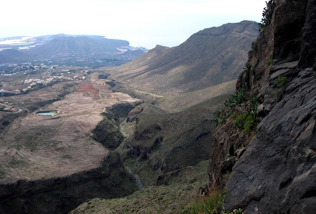
Close by is Montaña Béñamo, a sacred Guanche site where once existed a tagoror, or circle of stones on the peak, where the community leaders held meetings. The hill was also reputed to have had trees growing on the summit which were cut down and used in the building of the original chapel. From here, I followed a track passing terracing to arrive at the Barranco De Herques, an impressive example dividing the municipalities of Güimar and Fasnía.

Herques ravine

In 1770, naturalist José de Viera y Clavijo discovered a high ceilinged cave in the ravine and wrote that it was ' full of mummies, counting no less than one thousand'. The location of the cave appears to have since been lost in time once again, despite subsequent numerous attempts to re-locate it.

Path into the ravine

Descending steeply into the barranco, I reached the streambed and admired caves in the walls that now towered over me before climbing out and passing a small reservoir and an information board detailing past struggles to irrigate this arid region before the gallerias were drilled in the 1930's. 

Caves in the ravine

Reaching a rural road I followed it back up to the TF28, which I followed across the Barranco de Herques once again, before eventually arriving back in El Escobonal.

Reservoir

The camino real had been very easy to follow because of the excellent signposting and the information boards had made it an interesting walk but until I started investigating the purpose of the signposts, which I had seen from the TF28 while driving by, I had no idea of the walks existence. Surely, if money is going to be spent marking these walks and putting up information boards along the routes, it would make sense to produce proper guidebooks in various languages ​​to promote them to walkers.

Bridge on the TF28 over the ravine

Once back in El Escobonal, the directions I had obtained from the internet advised me to pay a visit to the Archaeological and Ethnographic museum in San Jose plaza. Unfortunately, when I got there, it was closed for 'reforms' and I had to chuckle quietly to myself as the completion dates for these 'improvements' was February 2011! It seems that the somewhat haphazard approach to promoting tourism on the island extends beyond walking.