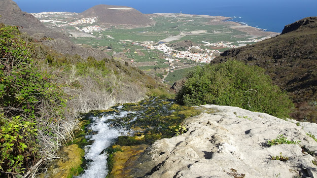
Today, I set off on a walk to the mostly abandoned settlement of Cuevas Negras, deep in the laurel forest in the Barranco de Las Cuevas Negras, in the Teno Mountains in north-west of Tenerife . Starting from the village of Erjos, I descended steeply before leaving the path after a couple of miles to the village of Tierra del Trigo. After climbing out of the Barranco de Las Cuevas Negras, I paused for a break by some abandoned buildings on the Lomo del Topo from where I had stunning views to Los Silos and the Isla Baja. After my break, I continued towards the village of Tierra del Trigo and just before the village, took a path running alongside a water channel filled with water rushing down the hillside. The path ended where the water channel finished, with the water then simply tumbling down the hillside. This is the Cascada Lomo Morin, which in the bottom of the valley, becomes an impressive waterfall. Unfortunately, the path to the falls in the valley has become so popular with walkers posting photos and video of themselves standing under it on social media that it has been closed to walkers by the addition of a locked gate at the start of the path. The number of walkers using this unofficial path had become a problem for local people working in the area so the authorities felt it necessary to take action. Having enjoyed the view from the top of the cascade, I made my way to the village before climbing steeply back to Erjos, which was something of a slog in the heat. Despite this, the views throughout the walk were simply stunning.
The Canal de Vergara & Black Mountains
A video taken last week from a hike and overnight camp on the edge of the National Park. I hiked up from Chio late afternoon and pitched my tent just as the sun was setting on the edge of the Teide National Park. The stars were incredible! The following morning, I got up in time to watch the sun come up and hiked to the summit of Montaña de La Botija for some stunning views before hiking back down to Chio.
Montaña Colorada & Las Casas de Teresme
This walk started from the Las Lajas recreation and camping area on the Teide road above Vilaflor. The route initially followed the marked trail to Adeje as it headed for Montaña Colorada, which certainly lived up to it's name 'Red Mountain'. The next landmark was the ruins of the Casa de Teresme, where I paused for a break as the cloud slowly began building up. I then crossed a number of barrancos and in the first of these I passed the Galeria El Rosario before climbing steeply out and heading towards Alto de Chimoche. After crossing the Barranco del Agua and Barranco del Rey,I descended via Guayero to Ifonche before finishing in Arona. The whole walk was 13.5 miles/21.7 kilometres and took 7.25 hours, passing through some quiet, spectacular countryside, although some of the far reaching views to the coast were spoilt by the haze.
Climbing Montaña Blanca in Tenerife
Yesterday's walk took me from the lower cable-car station to the summit of Montaña Blanca, which is a hill on the flanks of Teide reaching just over 9,000ft in altitude. The path is signposted from the roadside below the cable-car station and is easy follow as it passes through the awesome, other-wordly landscape of the Las Cañadas National Park. Crossing the road at the small Montaña Blanca parking area, I joined the crowds of people heading up towards the start of the Teide path. The initial trail is a fairly easy, steady climb on a wide track in incredible scenery with views across to La Foretleza and the bulk of Teide looming above. Soon, the path passes the Huevos del Teide or Teide Eggs. These huge boulders are giant accretion balls, formed as they rolled downhill on slow moving lava flows and gaining in size like huge snowballs. Soon, I reached the split in the path where the path to Teide turned right and I watched the line of people heading up into the cloud that had now formed on the volcano as I headed left to the top of Montaña Blanca. The views from the top were superb but there was a very cold wind blowing so I didn't linger long before turning and heading back.
A Las Lajas circular walk
Montana Colorada |
Las Lajas is a campsite and recreation area sitting at around the 7,000ft/2,100mtr altitude on the main road from the south of the island to the Teide National Park. I set out on this walk on a beautiful morning and headed for a path contouring around Montana de Las Lajas and descended a very steep, slippery and eroded path enjoying the stunning views towards the south coast and to nearby Montana Colorada.
A walk from Chio along the Canal de Vergara
This weekend, I walked from the hill village of Chio in the south-west of the island and climbed 1,000 metres before descending to the Canal de Vergara. This was a continuation of walk I started a couple of years ago when I hiked to the source of the water channel in the Barranco de Vergara on the northern slopes of Teide and then followed the water channel for many kilometres, sometimes hiking on top of it.
The Lighthouse at the End of the World
Eucalyptus
and almond blossom. The church square and picnic zone look and smell
wonderful in the bright morning sun. The square is dotted with
tourists taking photos and enjoying the quiet of the simple but
attractive church and the trees bedecked in the pink of the blossom.
I do the same as I take my photos and enjoy the ambience but this is
probably my only connection with these holidaymakers. I look at my
watch, it is 10.50 am and I turn and leave the square and the idyllic
scene and take the first steps towards my destination.
A Walk Through Tenerife's Past
El Roque at the start of the walk |
Montaña Sámara & the Las Cuevas Negras
![]() |
View from the summit of Montaña Sámara |
This walk was a new route in an area that I had intended investigating for some time so I was pleased to find details on the web about a new path leading from Montaña Sámara to the Cuevas Negras, a series of lava tubes just off of the path in the volcanic landscape below the slopes of Pico Viejo. There is a convenient car park just below the Montaña Sámara cone and after parking the car I was soon climbing up the cinder path to the summit. The views from the top were simply stupendous and far-reaching to the summits of Pico Verde and Pico de Gala in the Teno range with the twin summits of the island of La Palma in the clouds beyond providing a fitting backdrop.
Las Cañadas to Poris de Abona - A walk from Summit to Sea
The 'El Filo' path is a route in the Las Canadas National Park that starts from the TF24 road close to El Portillo and initially follows a broad track through the desert scenery of the park as it weaves through the Tiede Broom and heads towards the parador. I recently set off on a two day hike following the path as it wound it's way through the parched landscape typically found in this part of the park. Being summer, the weather was very hot and as I could not be sure that I would be able to replenish my water supplies, I carried around 7.5 litres in my pack, which made it quite heavy when combined with my camping gear.
Subscribe to:
Posts (Atom)

